

Ravish Handoo
The northern edge of South America presents a landscape of breathtaking beauty, where the towering Andes mountains meet the Caribbean Sea. Yet, beneath this picturesque surface lies one of the most geologically volatile zones on the planet. Venezuela, a nation of rich cultural history and vibrant urban centers, lives in perpetual negotiation with the earth beneath its feet. The recent occurrence of devastating twin earthquakes, registering massive magnitudes of 7.2 and 7.5, serves as a stark and tragic reminder of the immense tectonic forces shaping this region. To understand why Venezuela is uniquely susceptible to such powerful and destructive seismic events, one must delve into a complex interplay of tectonic geography, the physics of seismic wave propagation, local geological formations, and the vulnerabilities of the human built environment.
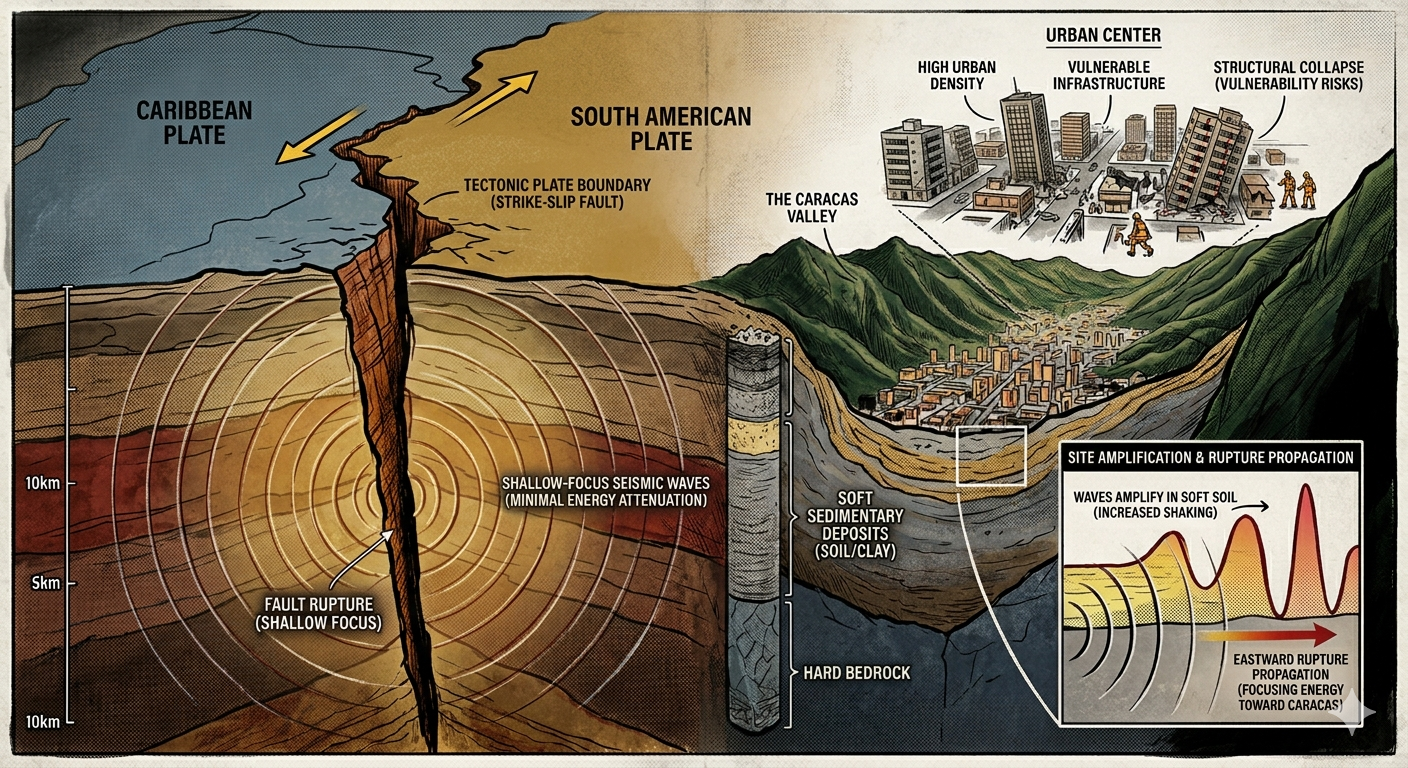
At the very heart of Venezuela’s seismic peril is its location at a major planetary crossroads. The entire northern region of the country serves as the active boundary where the Caribbean Plate and the South American Plate collide and grind past one another. Tectonic plates are massive slabs of the Earth’s lithosphere that are constantly in motion, driven by the churning currents of the mantle far below. In the case of northern Venezuela, these two plates are locked in a complex, strike-slip fault system. Instead of sliding past each other smoothly, the jagged edges of the plates catch on one another. As the plates continue their inexorable drive, the friction along the fault line prevents them from moving, causing an immense amount of elastic strain and mechanical stress to accumulate in the crustal rocks over decades, centuries, or even millennia. When the stress finally exceeds the structural strength of the rock, the fault snaps. The crust abruptly ruptures, and the accumulated energy is released instantaneously, radiating outward in all directions as seismic waves that violently shake the surface. This continuous cycle of stress accumulation and sudden release is the foundational reason why the north-central region of Venezuela, which hosts the vast majority of the nation’s population, is a high-risk seismic zone.
While the overall magnitude of an earthquake provides a measure of the total energy released at its source, it is only one piece of the puzzle when it comes to determining the level of destruction on the surface. The depth at which the rupture occurs plays an equally vital role. The powerful earthquakes that recently struck Venezuela were classified by seismologists as shallow-focus events, meaning their hypocenters were located very close to the surface, typically at depths of around ten kilometers or less. This shallow depth is a critical factor in why these specific earthquakes proved so catastrophic. When an earthquake occurs deep within the Earth’s mantle, the seismic waves must travel through dozens or hundreds of kilometers of dense rock to reach the surface. As they travel, the waves undergo a process known as attenuation, where the Earth acts as a natural dampener, absorbing and scattering the energy, thereby reducing the intensity of the shaking by the time it reaches human settlements. In contrast, with a shallow-focus earthquake, there is very little rock between the rupture point and the surface. The primary and secondary seismic waves reach the surface almost immediately with their destructive energy completely intact. The result is an incredibly violent, high-frequency ground shaking that delivers a sudden, hammer-like blow to anything standing directly above.
The devastation of these recent earthquakes was further compounded by a phenomenon known as directional rupture propagation, which effectively placed Venezuela’s capital city, Caracas, directly in the crosshairs of the disaster. Even though the epicenters of the twin shocks were situated roughly one hundred and sixty kilometers to the west of the capital, Caracas bore the brunt of the catastrophic damage. Seismologists analyzing the event noted that when the fault split open, the rupture did not spread out evenly in a circle; instead, it zipped eastward along the fault line like a tearing seam, moving directly toward the capital. This directional tearing created a compounding effect, pushing the seismic energy ahead of the rupture front and focusing a disproportionate amount of the earthquake’s power straight toward the urban center. By the time the seismic waves arrived in Caracas, they were packed with far more intensity than if the rupture had moved in the opposite direction.
When this concentrated beam of seismic energy finally reached Caracas, it collided with the unique and unfortunate local geology of the city itself. Caracas is built inside a prominent mountain valley, a setting that provides beautiful geography but terrible seismic physics. The valley floor is not solid bedrock; rather, it is filled with deep, soft layers of sedimentary deposits, composed of loose soil, clay, and gravel washed down from the mountains over millions of years. When fast-moving seismic waves travel through the dense, hard rock of the earth’s crust and suddenly hit a pocket of deep, soft sediment like the Caracas valley, their behavior changes dramatically. The waves slow down significantly because the loose material offers less resistance. However, to conserve their total energy as they slow down, the waves must grow in amplitude, meaning the physical height and power of the ground vibrations multiply exponentially. This process, known as seismic site amplification, essentially turns the soft valley floor into a giant amplifier, causing the buildings constructed upon it to sway and shake with much greater violence and for a significantly longer duration than structures built on the surrounding solid rock mountainsides.
Ultimately, the science of geology and seismology only explains how the earth moves; it is the intersection of these natural forces with human civilization that transforms a physical hazard into a human tragedy. A fundamental rule of disaster science dictates that an earthquake itself does not kill people; rather, it is the collapse of human-made infrastructure that causes casualties. In Venezuela, this vulnerability is deeply acute due to a combination of high population density and socioeconomic challenges. The major fault lines of the country run directly beneath its largest cities, meaning millions of people are living on top of a geological time bomb. Over decades of rapid urbanization, many residential neighborhoods and critical infrastructure projects were constructed without strict adherence to modern seismic building codes, or were built using older materials and techniques that simply cannot withstand the violent, high-frequency shifting of a shallow-focus earthquake. Economic hardships in recent history have further constrained the resources available for retrofitting older buildings, reinforcing bridges, or implementing widespread civic preparedness campaigns. When the earth finally shifted, these structural and societal vulnerabilities collided with the unyielding physics of the plates, resulting in widespread structural failure and a heartbreaking loss of life. Understanding these interconnected factors—from the massive movements of the Caribbean and South American plates to the specific architectural integrity of urban housing—is essential if the nation is to rebuild safely and prepare for the inevitable movements of the earth in the future.
